


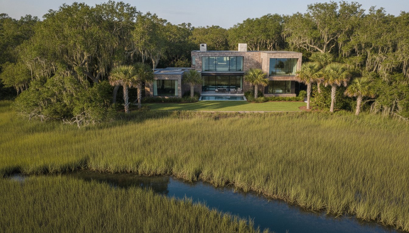
A recent study from the National Association of REALTORS revealed that homes featuring high-quality aerial photography sell 68% faster than those without it. In a market as nuanced as the South Carolina Lowcountry, the difference between a successful closing and a stagnant listing often comes down to spatial context. You likely recognize that ground-level shots cannot fully capture a residence's proximity to the Calibogue Sound or the sweeping geometry of a custom build in Palmetto Dunes. However, the prevalence of overprocessed, distorted drone imagery often devalues the very luxury it intends to showcase.
This discussion reframes hilton head drone photography for real estate as a disciplined architectural lens rather than a marketing gimmick. We'll explore how professional aerial imagery establishes geographic context while respecting the strict FAA compliance and HOA regulations found within Hilton Head's private clubs. You'll discover a philosophy of visual storytelling that prioritizes natural light and structural realism over artificial enhancements. We'll also provide a technical overview of navigating the island's unique airspace to ensure your next high-intent listing stands out with quiet, sophisticated authority.
Key Takeaways
• Redefine aerial imagery as a strategic architectural tool that emphasizes spatial clarity and the property's relationship with the unique Lowcountry environment.
• Ensure legal and community compliance by understanding FAA Part 107 requirements and the specific drone restrictions within private clubs like Sea Pines and Palmetto Bluff.
• Master the art of the "geographic narrative" to effectively communicate a listing's proximity to waterfront amenities and golf courses that ground-level photography cannot reach.
• Elevate your marketing portfolio with hilton head drone photography for real estate that prioritizes natural light sophistication and technical precision over trendy, distorted visuals.
Beyond the Bird's Eye View: Redefining Aerial Imagery in the Lowcountry
The evolution of property presentation has reached a point where mere elevation is no longer a differentiator. In the high-end markets of Bluffton and Hilton Head, the objective isn't just to show a roofline but to tell a story of site integration. Sophisticated hilton head drone photography for real estate functions as an "environmental portrait." It captures the home not as an isolated object, but as a deliberate part of the Lowcountry landscape. This shift moves away from the "sizzle" of marketing hype and toward the discipline of architectural documentation. We prioritize craftsmanship and spatial logic over the "new money" aesthetics often found in generic real estate media. By treating the drone as a strategic tool, we provide a perspective that respects the architect's original vision and the property's natural context.
The Pitfalls of Traditional Real Estate Drones
Many listings suffer from what we call "toy-like" imagery. This is characterized by overprocessed HDR, artificial sky replacements, and the use of ultra-wide lenses that distort structural proportions. These techniques might attract quick clicks on social media, but they often alienate discerning buyers who value authenticity and craftsmanship. When a sky looks impossibly blue or the colors appear radioactive, the architectural integrity of the home is compromised. Effective hilton head drone photography for real estate requires restraint. A professional approach avoids these visual gimmicks, focusing instead on spatial clarity and natural light sophistication that reflects the actual experience of the property. This commitment to realism ensures that the first impression is one of trust and quality rather than digital manipulation.
Establishing a Geographic Narrative
While Aerial photography has a long history of documenting land use, its role in luxury real estate is to establish a clear geographic narrative. For a waterfront home in Sea Pines or a golf-front estate in Wexford, the drone serves as the bridge between ground-level detail and the surrounding environment. It documents the transition from the tidal marsh to the manicured lawn, and finally to the custom architecture. This perspective provides buyers with a sense of scale and location that ground shots cannot convey. By utilizing tonal restraint and professional photography techniques, we ensure the property is presented with the quiet confidence it deserves. This isn't about flashy flyovers; it's about providing the technical evidence of a home's premier position within the Hilton Head ecosystem. It’s about documenting the property's orientation to the sun, its proximity to the Atlantic, and its relationship with the live oaks that define our region.
The Architectural Utility of Aerial Perspectives
While many view aerial imagery as a supplementary marketing asset, its true value in the luxury sector lies in its capacity for architectural literacy. High-end residences in communities like Colleton River or Berkeley Hall are often complex compositions that ground-level photography cannot fully decode. To provide a comprehensive understanding of a property, one must document the structural logic that informs its placement. The National Association of REALTORS® has tracked the steady rise of drone use in the real estate industry, but the distinction for luxury listings is found in how that technology is applied. Rather than seeking a generic bird's-eye view, sophisticated hilton head drone photography for real estate focuses on the utility of the perspective, revealing the residence's footprint and its deliberate site integration.
Spatial Clarity and Site Integration
Aerial perspectives allow potential buyers to appreciate the architect's original intent regarding the building's orientation and flow. In the Lowcountry, where the relationship between indoor living and outdoor amenities is paramount, a vertical view clarifies how a screened lanai, a summer kitchen, and a pool deck interact. This spatial clarity is essential for properties with sprawling layouts or multiple structures. Architectural drone photography is the disciplined application of aerial perspectives to document the site-specific design, structural footprint, and environmental integration of a residence. By capturing these relationships, we provide a visual map that ground-level shots simply lack. This approach is particularly effective for custom home builds where the layout is a unique response to the specific topography of the lot.
Documenting Craftsmanship from Above
The utility of a drone extends to the fine details of a home's exterior envelope. At specific altitudes, we can maintain realistic proportions while highlighting the craftsmanship of high-end materials that are otherwise difficult to inspect. This includes:
Custom Masonry and Hardscapes
Documenting the intricate patterns of tabby shell driveways or hand-laid stone pathways.
Landscape Architecture
Showcasing the mature canopy and the structured gardens that define a private estate.
Roofing and Exterior Textures
Providing a clear view of slate tiles, copper flashing, or cedar shakes that signify a premium build.
Maintaining a sense of scale is critical. We avoid the distortion of ultra-wide lenses to ensure that the property's proportions remain true to life. Utilizing hilton head drone photography for real estate to highlight these elements reinforces the integrity of the build in relation to neighboring estates. When documenting these intricate details, our team prioritizes technical precision to ensure every architectural photography session delivers a true-to-life representation of the build. This commitment to realism ensures that the visual narrative remains grounded in the actual quality of the craftsmanship.
Navigating Hilton Head’s Private Club Communities and FAA Regulations
Executing high-caliber hilton head drone photography for real estate involves more than technical skill; it requires a deep understanding of the legal and social frameworks that define our region. Commercial drone operations are governed by strict federal mandates. Every pilot must hold a Remote Pilot Certificate under Part 107, a requirement that ensures the safety of the national airspace. As of March 2024, the Remote ID mandate adds another layer of accountability, acting as a digital license plate for every registered aircraft. Beyond these FAA regulations, the private club communities of the Lowcountry maintain their own rigorous standards for "quiet enjoyment." Communities like Sea Pines and Palmetto Bluff often require prior authorization from the Property Owners Association (POA) before any flight can occur. This dual layer of oversight protects the privacy of residents and the integrity of the community's atmosphere.
Compliance Checklist for Gated Communities
Operating within restricted Hilton Head airspaces, particularly near the Hilton Head Island Airport (HXD), requires professional coordination. We manage the logistical hurdles so agents and builders don't have to. Our standard protocol for private club environments includes:
LAANC Authorization
Securing immediate digital approval for flights in Class D controlled airspace.
Security Coordination
Notifying plantation security and management to ensure all gate access and flight paths are pre-approved.
Non-Intrusive Documentation
Maintaining a professional distance from neighboring residences to respect the privacy of the surrounding estate owners.
Liability Verification
Ensuring full commercial insurance coverage is active for every mission, protecting all parties involved in the listing.
The Ethics of Aerial Realism
In luxury real estate, trust is the most valuable currency. While some providers rely on artificial sky replacements or over-saturated colors to "fix" a shot, we believe these practices create unnecessary buyer friction. Deceptive imagery might look appealing on a screen, but it fails the reality test during an in-person showing. Our philosophy of architectural photography centers on documenting true coastal conditions. We capture the Lowcountry's natural light as it is, reflecting the genuine atmosphere of the property. This commitment to realism ensures that the visual narrative remains honest. When a buyer arrives at a waterfront estate in Bluffton, the transition from digital preview to physical experience should be seamless. By avoiding artificial enhancements, we preserve the architectural integrity of the build and foster a transparent relationship with high-intent buyers.
Integrating Aerial Imagery into a Cohesive Property Narrative
Effective property presentation is a study in pacing. Rather than delivering a disparate collection of files, a professional approach treats every image as a component of a larger narrative. Sophisticated hilton head drone photography for real estate serves as the "chapter markers" for this story. It provides the necessary transitions that allow a viewer to move mentally from the broad Lowcountry environment into the intimate details of a home. By selecting specific altitudes, we create a logical visual flow that grounds the architecture in its surroundings before inviting the viewer inside.
The Visual Sequence
A compelling presentation follows a deliberate arc. We begin with the environment, using high-altitude site overviews to establish the property's relationship with the coastline or golf course. This is followed by mid-level shots that define the build's presence and structural footprint. Finally, we utilize low-level lifestyle perspectives to highlight outdoor amenities like infinity pools or custom hardscapes. This sequence ensures the viewer never loses their sense of place. The synergy between drone real estate photography and interior stills is what creates a truly cohesive portfolio, bridging the gap between the exterior landscape and the internal craftsmanship.
Leveraging Video for Immersive Tours
The narrative depth of a listing is further expanded through real estate videography. Utilizing professional hilton head drone photography for real estate alongside cinematic motion creates a multi-dimensional perspective of the estate. We prioritize slow, deliberate tracking shots that mimic the natural eye's movement, avoiding the fast, distracting transitions common in lower-end marketing. This professional footage is particularly effective for social media marketing, where it can capture the attention of high-intent buyers in a crowded digital landscape. It's about creating a refined visual journey that reinforces the property's value at every turn.
To ensure your next listing benefits from this strategic narrative approach, book your professional architectural session with our team today.
Elevating Your Portfolio with Houzpics Aerial Expertise
Choosing a media partner is a reflection of your own brand's standards. At Houzpics, we recognize that luxury listings in the Lowcountry require a level of sophistication that goes beyond standard marketing. Our execution of hilton head drone photography for real estate is built on a foundation of architectural literacy and technical precision. We prioritize the structural narrative of a property, ensuring that every aerial perspective reinforces the craftsmanship and intent behind the design. This commitment to quality ensures that your portfolio maintains a consistent, high-end aesthetic that resonates with discerning buyers and professional peers alike.
Our commitment to professional restraint is particularly vital within the private club communities of Hilton Head and Bluffton. We understand the nuances of operating in environments like Wexford or Colleton River, where neighbor privacy and community standards are paramount. By maintaining a quiet, professional presence and adhering to all FAA and POA regulations, we provide a service that is as reliable as it is visually compelling. This technical credibility allows us to function as a seamless extension of your professional team, providing customized aerial solutions for architects, custom builders, and luxury agents who refuse to compromise on quality.
A Strategic Partnership for Growth
The impact of high-caliber imagery extends beyond a single listing. When your portfolio consistently features refined, editorial-quality visuals, it improves the quality of your professional sales interactions. Potential clients recognize the investment in craftsmanship, which builds trust before the first conversation even begins. Our work is designed to highlight the strengths of your builds and listings, providing the visual evidence needed to secure high-value contracts. The Houzpics approach is a shared journey toward architectural excellence, where our technical expertise serves to amplify the quality of your professional dialogue. We focus on long-term brand authority, ensuring that your marketing materials remain timeless rather than trendy.
Booking Your Lowcountry Session
Streamlining the production process is essential for busy professionals. We've designed our workflow to be efficient and transparent, from the initial site assessment to the final delivery of your assets. Scheduling an architectural drone session is a straightforward process that prioritizes your project's timeline and the optimal lighting conditions for the property. Once the shoot is complete, you can access your high-resolution imagery and video through our professional property photography portal. This centralized system allows for easy downloading and organization of your marketing assets, ensuring you have the tools you need to launch your listing with confidence.
Ready to showcase your next project with the sophistication it deserves? Schedule your architectural photography session with Houzpics and experience the difference that professional architectural literacy brings to your portfolio.
Defining the Standard for Lowcountry Architectural Presentation
The transition from a standard listing to a compelling architectural narrative requires a disciplined approach to visual documentation. We've explored how sophisticated hilton head drone photography for real estate establishes geographic context while respecting the structural integrity of a residence. By prioritizing natural light realism and tonal restraint, you ensure that every aerial perspective reinforces the property's value rather than distracting from it with overprocessed gimmicks. This method transforms a simple view into a strategic asset that communicates site-specific design and environmental integration to high-intent buyers.
Our team of FAA Part 107 Certified Pilots specializes in the nuances of Lowcountry coastal architecture, navigating the specific regulatory hurdles of private clubs with professional ease. We don't just capture images; we provide a strategic partnership that elevates your entire portfolio through meticulous quality control. This commitment to technical excellence and spatial clarity allows you to present every estate with the quiet authority it deserves. As the market continues to favor transparency and craftsmanship, your choice of media partner becomes a defining element of your brand's reputation.
Secure your architectural property session through our portal and experience a more refined approach to property presentation. We look forward to documenting your next landmark project with the precision it requires.
Frequently Asked Questions
Do you need a license for real estate drone photography in Hilton Head?
Commercial drone operations legally require an FAA Remote Pilot Certificate, known as Part 107. This federal mandate applies to all real estate marketing activities. Our pilots maintain current certification and adhere to all registration and Remote ID requirements to ensure full legal compliance for your listing.
How do drone photos benefit a real estate listing in the Lowcountry?
High-quality hilton head drone photography for real estate reveals the residence's proximity to the coastline, marshlands, or golf amenities. It provides a strategic view of the property's footprint and site integration that ground shots cannot replicate. This environmental context is essential for luxury buyers evaluating the estate's premier location.
Can drones fly in gated communities like Sea Pines or Palmetto Bluff?
Drones can operate in private communities, but they require prior authorization from the Property Owners Association. Communities like Sea Pines and Palmetto Bluff have specific regulations to protect resident privacy. We coordinate directly with plantation security and management to secure the necessary permits before every flight.
What is the best time of day for aerial real estate photography?
The best time for aerial work depends on the property's orientation to the sun. We typically favor the "golden hour" or times when the sun angle highlights the architectural textures and depth of the build. This natural light sophistication ensures spatial clarity and avoids the harsh shadows that can obscure structural details.
How many drone shots are typically included in a real estate package?
The number of shots depends on the architectural complexity and the narrative goals of the presentation. A standard session focuses on capturing the essential geographic context and structural footprint. We prioritize high-quality, purposeful compositions over a high volume of generic angles to maintain the integrity of the property narrative.
Are drone photos legal if the property is near the Hilton Head Airport?
What happens if the weather is bad on the day of the scheduled drone shoot?
We monitor coastal conditions closely and will reschedule sessions if the weather compromises safety or visual quality. High winds or precipitation prevent flight, but we also consider cloud cover and light quality. Our goal is to capture the property in optimal conditions to reflect its true architectural beauty.
How does drone photography differ for raw land versus luxury estates?
Photography for raw land focuses on boundary identification and topographical scale. For luxury estates, the focus shifts to architectural storytelling and the relationship between the structure and its amenities. Each approach requires a different technical lens to effectively communicate the value of the specific site.


