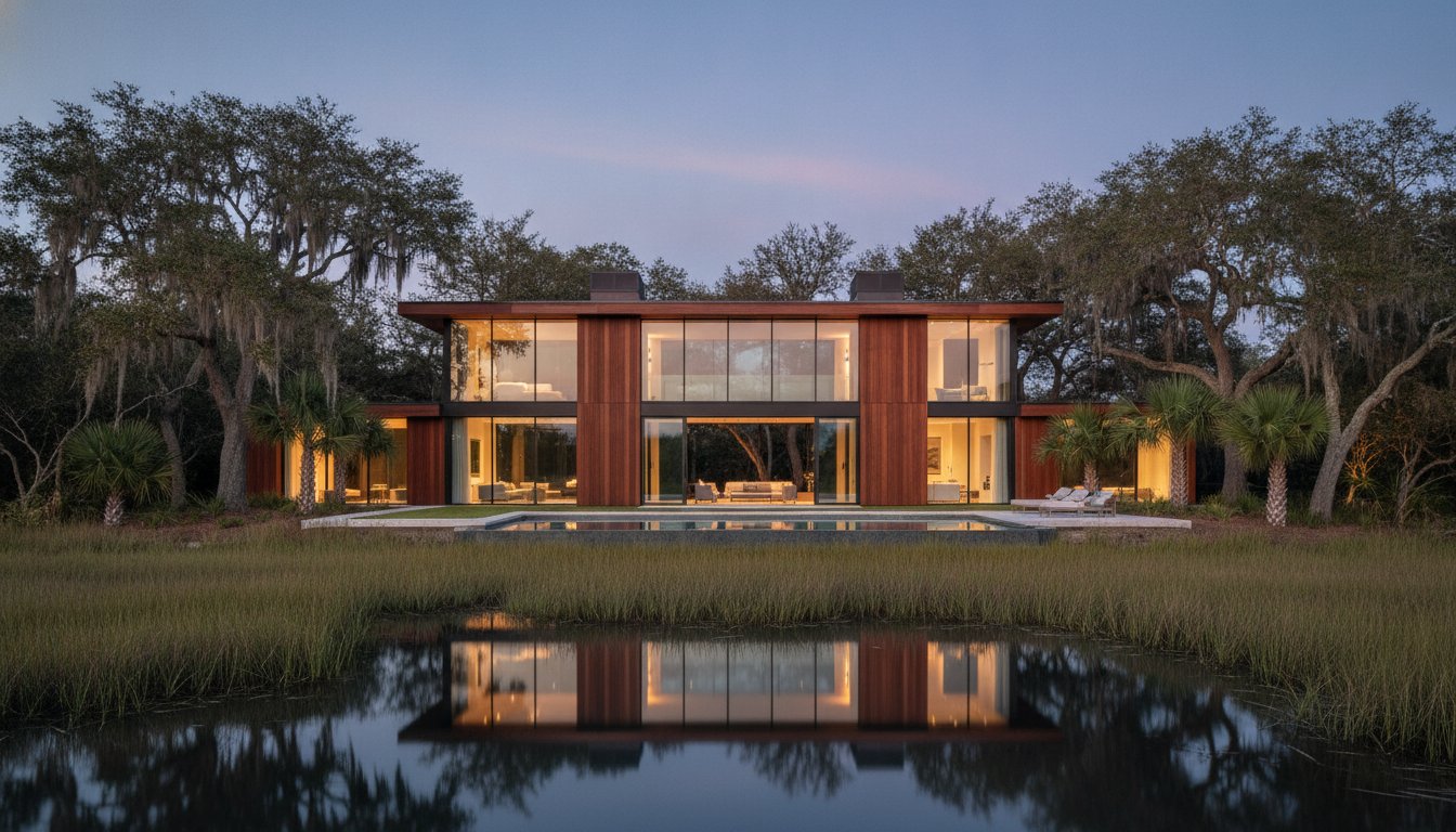
In the Hilton Head and Bluffton markets, altitude affects attitude more than almost any interior renovation. You likely recognize that a standard ground-level photo often fails to capture the true value of a marshfront lot or a home tucked away in a premier golf community. Buyers looking for coastal homes in the Lowcountry aren't just buying four walls; they're investing in a specific lifestyle defined by the water and the landscape. Using drone real estate photography is the only way to truly show that connection.
This guide will show you how aerial imagery transforms listings by revealing the precise relationship between a property and its surroundings. It's the most effective tool to show a buyer exactly how close they are to the Atlantic Ocean or the nearest fairway. We'll cover how to capture these views while respecting privacy and FAA regulations. You'll also learn how to find a reliable Hilton Head listing photographer or a specialist in real estate photography Bluffton SC who understands the unique needs of our resort and retirement markets.
Key Takeaways
• Understand why altitude is essential for showcasing a property's proximity to Lowcountry marshes, waterways, and golf course fairways.
• Discover how drone real estate photography provides a professional and accessible way to capture the layout of complex coastal resort communities.
• Learn the importance of FAA Part 107 certification and how to navigate specific flight restrictions within private Bluffton and Hilton Head neighborhoods.
• Identify the specific preparation steps needed to ensure your home’s exterior and landscaping look pristine from a top-down aerial perspective.
• Explore how professional aerial marketing helps elevate listing presentations and captures the attention of out-of-state buyers looking for a lifestyle change.
What is Drone Real Estate Photography?
Professional drone real estate photography is the practice of utilizing unmanned aerial vehicles (UAVs) to capture high-definition imagery and video from an elevated perspective. In the South Carolina Lowcountry, this technology provides a vantage point that ground-based equipment simply cannot replicate. It allows potential buyers to see a property in its entirety, including its relationship to the surrounding marshlands, tidal creeks, and golf courses. Aerial photography has existed for over a century, but the transition from expensive manned aircraft to precision drones has changed the way we market homes in Bluffton and Hilton Head.
The technology has shifted rapidly over the last decade. Before 2014, capturing an bird's eye view typically required hiring a helicopter pilot, making it cost-prohibitive for most listings. Today, professional drones equipped with 1-inch CMOS sensors and 20-megapixel cameras deliver crisp, architectural-grade detail at a fraction of the historical cost. These high-resolution sensors are vital for capturing the fine textures of tabby exteriors and cedar shake roofs while maintaining the vibrant greens and blues of our coastal landscape.
The Evolution of Aerial Marketing
Aerial views have transitioned from a luxury add-on for multi-million dollar estates to a standard requirement for competitive listings. While it's easier than ever for hobbyists to explore Consumer Drones, professional drone real estate photography requires specialized equipment designed to handle coastal wind speeds and high-glare environments. Professional systems provide stabilized, distortion-free angles that highlight the layout of a multi-acre estate in Okatie or the intricate rooflines of Lowcountry architecture. These images help establish a property's scale and orientation, which are details often lost in traditional photography.
Why Real Estate Agents Use Drones in South Carolina
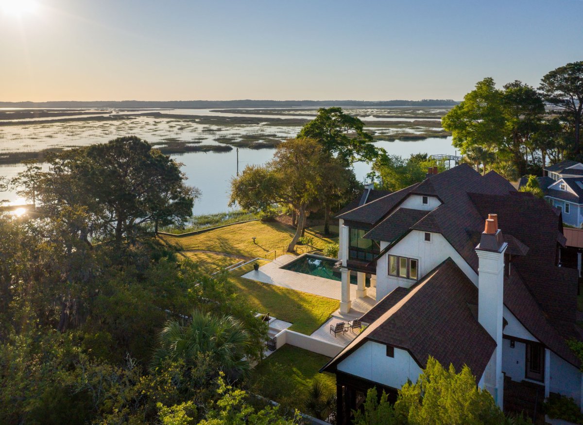
Real estate agents in the Hilton Head and Bluffton markets face a specific challenge. A large percentage of potential buyers are "snowbirds" or out-of-state investors who begin their property search online from hundreds of miles away. These buyers need to understand the "sense of place" before they commit to a site visit. In resort communities like Sea Pines or Hilton Head Plantation, a drone shot can show the exact walking distance from a front door to the Atlantic Ocean or the nearest fairway.
For large coastal estates and multi-acre lots in Bluffton, ground photos rarely convey the true scale of the land. Aerial imaging clarifies property boundaries and highlights premium features like private deep-water docks, wrap-around porches, and mature live oak canopies. This visual data helps differentiate a listing in high-volume markets, where providing a perfect first impression is essential to shortening the sales cycle. By showcasing the lifestyle and the location simultaneously, drones help agents "elevate the conversation" with sophisticated buyers.
Why Altitude Matters for Hilton Head and Bluffton Listings
In the Lowcountry, a home is rarely just about the structure itself. It is about the relationship between the property and the surrounding ecosystem. Standard ground-level photography often fails to capture the 12 miles of beachfront in Hilton Head or the intricate tidal creeks of Bluffton. By utilizing drone real estate photography, we provide a perspective that ground cameras simply cannot reach. This altitude reveals the proximity to water, marshes, and golf course fairways that define the local lifestyle.
Aerial views also serve a practical purpose for discerning buyers. They show the scale of the roof and the condition of upper-level features like dormers or chimneys. High-resolution imagery ensures that every detail is precisely measured by the eye of the potential buyer before they even set foot on the property. This birds-eye view provides a comprehensive understanding of the neighborhood layout, which is a significant factor for those relocating to our area.
Capturing the Lowcountry Landscape
Many marshfront properties in communities like Moss Creek or Sea Pines have views that remain hidden from the street. A drone can rise above the dense canopy of live oaks and palmettos to frame a home within its natural environment. This perspective is vital for properties near the Atlantic coastline where the value is tied directly to water proximity. We ensure all operations follow FAA regulations for commercial drone use, providing peace of mind for both the agent and the homeowner. Capturing the way the light hits the water at golden hour can elevate a listing from a simple house to an aspirational lifestyle.
Showcasing Community and Lifestyle
For the 80% of buyers who begin their search from out of state, understanding a home's position within a resort community is essential. Professional drone real estate photography highlights nearby beach clubs, marinas, and tennis centers. It allows a buyer to see exactly how many yards separate their back deck from the third-hole fairway. This visual data helps buyers calculate their daily walk to the beach or their commute to the clubhouse.
When you view our professional photography services, you will see how we emphasize these lifestyle connections to help shorten the sales cycle. We focus on the details that matter to "snowbirds" and lifestyle-driven purchasers, ensuring they see the full value of the investment. Our goal is to provide a perfect first impression that leads to a successful listing presentation and a faster closing.

Navigating FAA Rules and Resort Community Restrictions
Commercial drone operations in the South Carolina Lowcountry require more than just a high-end camera. Every flight for the purpose of selling a property must be conducted by a pilot holding an FAA Part 107 certification. Hiring an unlicensed hobbyist or a friend with a drone isn't just a risk to the visual quality of your listing; it's a significant legal liability for the real estate agent and the homeowner. If an incident occurs during a shoot for drone real estate photography, insurance providers typically deny claims if the pilot was operating illegally without a commercial license.
Professional pilots manage rigorous flight logs and carry specialized liability insurance that protects all parties involved. This level of oversight is necessary because the airspace around Hilton Head and Bluffton is complex. We operate near the Savannah/Hilton Head International Airport (SAV) and the Beaufort Marine Corps Air Station (MCAS). These areas often require specific FAA authorizations before a drone can even leave the ground. A seasoned professional understands how to navigate these digital fences to ensure your marketing remains compliant and safe.
FAA Compliance and Safety
Safety is the foundation of every successful aerial shoot. We follow best practices for drone real estate photography by conducting pre-flight airspace checks and monitoring local weather patterns. In Beaufort County, sudden coastal winds can change flight conditions in minutes. Professional pilots use real-time data to decide when it's safe to fly, protecting your property and the surrounding neighborhood from unnecessary risk. This disciplined approach ensures that we capture the best possible angles while respecting federal law.
Respecting Gated Community Privacy
The Lowcountry is home to over 40 gated communities, each with its own set of rules regarding aerial filming. Locations like Sea Pines, Palmetto Bluff, and Wexford have strict Property Owners Association (POA) guidelines that go beyond FAA regulations. We work directly with security and management to secure the necessary permits and notify neighbors when required. This proactive communication prevents awkward encounters and ensures the filming process is seamless for the seller.
Ethical drone real estate photography focuses on the subject property while minimizing the intrusion on neighboring homes. We use specific framing techniques to highlight the listing's strengths without peering into a neighbor's backyard or windows. Our pre-flight checklists include community-specific requirements to ensure every shot aligns with local expectations. This level of respect for privacy is why top-producing agents trust us to represent their luxury listings in sensitive resort environments. If you are ready to showcase your property with professional precision, you can view our professional photography services to see how we manage these details for you.
Preparing Your Coastal Home for an Aerial Photoshoot
Aerial views are unforgiving. Unlike traditional photography, drone real estate photography captures the entire footprint of a property, including the roof, the backyard, and the neighboring street. A stray trash bin or a parked car in front of a $2 million Sea Pines estate can disrupt the visual flow and lower the perceived value of the listing. When we elevate the camera, we expose every detail of the property's maintenance and presentation.
Preparation begins at the curb. Clear the driveway of all vehicles, including guest cars and service vans. Move trash and recycling bins into the garage or behind a privacy fence. These small adjustments ensure the focus remains on the architecture rather than daily chores. Our experience shows that a clean, unobstructed view of the entrance helps shorten the home buying sales cycle by creating an immediate sense of luxury and order.
Exterior De-Cluttering for the Camera
Remove garden hoses, children's toys, and pet supplies from the yard. Drone sensors are sensitive enough to pick up a single bright orange dog toy near the patio or a tangled hose against the foundation. For homes with pools, remove the automatic cleaner and ensure the water is crystal clear; an aerial shot looks directly through the water to the bottom. If the pool has a cover, it must be fully retracted to showcase the water's color and the surrounding stonework.
Landscaping and Curb Appeal
From 100 feet in the air, the contrast between a green lawn and dark mulch defines the property lines. Ensure the grass is freshly mown and the edges are crisp. In communities like Palmetto Bluff or Colleton River, overhanging branches often obscure the architectural lines of the roof. Trimming these back ensures the camera captures the full scale of the home. Check the gutters and roof valleys for fallen pine needles or Spanish moss clumps, as these appear as dark blemishes in high-resolution drone real estate photography.
The success of a coastal shoot depends heavily on the sun's position. We prioritize the "Golden Hour," typically the last 90 minutes before sunset. In the Lowcountry, this light softens the harsh shadows of tall palmettos and live oaks, creating a warm glow that appeals to out-of-state buyers looking for a vacation lifestyle. A 5:30 PM shoot in June provides a completely different emotional response than a high-noon session. This timing highlights the textures of the marsh and the depth of the coastal landscape, turning a standard listing into a captivating visual story.
Ready to showcase your listing from its best angle? Book your professional photography session with our expert team today.
Professional Aerial Marketing for Lowcountry Properties
Houzpics integrates aerial views into a comprehensive marketing strategy rather than treating them as optional add-ons. We view every project as a "Success Partnership." This means we provide the visual tools you need to elevate your listing conversations and win more business. When you show a seller exactly how you'll showcase their property's relationship to the marsh or the fairway, you build immediate confidence. Our team covers the entire region, serving clients from Hilton Head Island and Bluffton to Savannah and Skidaway Island.
Consistency is the hallmark of a seasoned professional. In a market where high-stakes transactions are the norm, agents need a partner who delivers reliable results every time. We don't rely on hype or aggressive sales tactics. Instead, we use our 30 years of local experience to provide a quiet, effective conversion tool for your listings. This approach respects the homeowner and appeals to the sophisticated buyer profile common in our resort and retirement communities.
The Houzpics Advantage
Experience matters when capturing the specific atmosphere of the South Carolina coast. We've spent three decades studying how the light hits the Lowcountry landscape at different times of day. Unlike companies that outsource their post-processing, we use an in-house editing team to maintain premium standards across every image. Our drone real estate photography is designed for a natural integration with our professional property photography. This ensures the transition from ground-level shots to aerial views is seamless and professional.
Booking Your Lowcountry Session
We've streamlined the process to respect your time. You can manage your appointments and view your gallery through our client portal. During the session, we focus on capturing the lifestyle elements that out-of-state "snowbirds" and luxury buyers look for, such as dock depth or neighborhood amenities. Providing this level of detail helps shorten the sales cycle. By delivering a complete visual package, we help you present a property that stands out in a crowded online marketplace. High-quality drone real estate photography serves as a powerful first impression that drives engagement and leads to faster closings.
Take Your Lowcountry Property Marketing Higher
Success in the South Carolina resort market depends on how well you tell a property's story. In coastal communities like Hilton Head and Bluffton, buyers aren't just looking at a house; they're looking at a lifestyle. High-quality drone real estate photography provides the necessary perspective to showcase proximity to the water or a specific golf course. Our team brings 30 years of experience to every shoot, ensuring your listing captures the attention of serious buyers.
We understand the local landscape and the specific flight restrictions found in private plantations. Our FAA Part 107 certified and insured pilots handle the technical details and community approvals so you don't have to. By focusing on the unique features of the Lowcountry, we help you build trust with out-of-state purchasers. Professional visuals simplify the decision-making process and help you win more listing presentations.
Elevate your listing today; Book Now with Houzpics
Your next great listing deserves a perspective that matches its value.
Frequently Asked Questions
Do I need a permit for drone photography in Hilton Head resort communities?
You must have an FAA Part 107 certified pilot and specific permission from the local Property Owners Association (POA) to fly. Most Hilton Head plantations require a 24 hour notice and a valid commercial gate pass before any flight begins. We manage these logistics to avoid unauthorized flight fines that can reach 500 dollars. Following these local rules ensures your listing process remains professional and uninterrupted.
How much does drone real estate photography cost in Bluffton, SC?
Professional drone real estate photography in Bluffton typically ranges from 150 to 300 dollars when booked as an add-on to a standard shoot. Standalone aerial packages often start at 250 dollars for a full set of high-resolution images. These rates cover the pilot's time, specialized equipment, and custom editing. Investing in these views helps your property stand out in competitive markets like Palmetto Bluff or Hampton Hall.
Will the drone capture my neighbors’ houses too?
Aerial images naturally include neighboring properties to provide context for the home’s location within the Lowcountry landscape. We typically fly at an altitude of 100 feet to focus on your specific lot while showing the proximity to local amenities. During our editing process, we frame the shots to ensure your listing is the primary focal point. This approach shows buyers the neighborhood character without compromising the privacy of adjacent residents.
What happens if the weather is bad on the day of my Hilton Head shoot?
We reschedule your session if wind speeds exceed 20 miles per hour or if there's any active precipitation. High-quality drone real estate photography requires stable flight conditions and clear visibility to produce the best results. There's no additional fee for weather-related delays. We monitor the local forecast 24 hours in advance and usually find a new opening within 48 hours to keep your marketing timeline on schedule.
Can drones fly in gated communities like Sea Pines or Palmetto Bluff?
Drones can fly in these communities provided the pilot follows strict security protocols and FAA regulations. We maintain a 1 million dollar liability insurance policy, which is a standard requirement for commercial vendors entering these luxury plantations. We coordinate directly with the security gates to ensure we have the proper access for your scheduled shoot. This coordination allows us to capture the premium lifestyle views that resort buyers expect.
How long does a typical aerial photography session take?
A standard aerial session takes approximately 30 to 45 minutes to complete on-site. This window allows us to capture 10 to 15 different angles, including high-altitude neighborhood views and lower-level architectural shots. If your project includes aerial video, we may spend up to 60 minutes on the property. Our efficient process ensures we get the necessary shots quickly so we don't disrupt the homeowner’s daily routine or the listing schedule.
Are drone photos necessary for smaller homes in Okatie or Beaufort?
Aerial views are highly effective for smaller homes because they highlight the property's location relative to golf courses or tidal creeks. Even for a modest cottage, showing the distance to the water or a community park adds significant value. Since 90 percent of buyers start their home search online, these photos provide a strategic advantage. It's about selling the Lowcountry lifestyle and the specific spot in the neighborhood, not just the square footage.