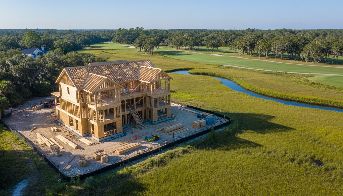
How many times has an out-of-state investor asked for a project update, only for you to realize that a ground-level photo doesn't show even 10% of the progress across a 20-acre marshland site? Managing large-scale developments in the Lowcountry presents unique challenges, from navigating tidal shifts to documenting expansive golf communities. Utilizing aerial photography for construction projects hilton head is no longer a luxury for modern developers; it's a critical tool for oversight. When you're building in resort markets like Bluffton or Hilton Head, you need more than just snapshots. You need a comprehensive view that bridges the gap between the job site and the boardroom.
You likely agree that keeping stakeholders informed and marketing luxury builds requires a level of precision that traditional photography can't provide. This guide explains how professional aerial imagery streamlines your construction management and accelerates your sales cycle for Hilton Head and Bluffton developments. We'll look at how these assets help you elevate conversations with investors and create the high-end marketing materials necessary to stand out in a crowded resort market.
Key Takeaways
• Understand why traditional ground-level photography fails to capture the scale of coastal estates and how high-altitude views provide essential context for Lowcountry developments.
• Learn to document the entire project lifecycle with a scheduled flight plan that tracks milestones from initial land clearing to the final vertical build.
• Discover how professional aerial photography for construction projects hilton head can secure early sales by showcasing future views to out-of-state buyers and snowbirds.
• Navigate the complexities of local airspace regulations and FAA Part 107 requirements specifically for the Hilton Head and Bluffton corridor.
• Explore the benefits of a relationship-driven partnership with a seasoned professional who understands the unique geographic challenges of South Carolina resort communities.
Why Aerial Views are Essential for Hilton Head Construction Management
A standard camera on a tripod cannot show how a new foundation sits relative to a tidal creek or a nearby fairway. In communities like Sea Pines or Palmetto Bluff, projects often span several acres. Capturing the entire footprint in one frame helps project managers spot potential drainage issues or staging conflicts before they become expensive delays. With 30 years of experience in capturing the local landscape, we understand that a project's success often depends on how well it integrates with its surroundings.
Visualizing the Lowcountry Landscape
Developers in Hilton Head and Bluffton face unique environmental constraints. Aerial views make it easier to monitor the buffer zones around protected wetlands and ancient live oaks. In Okatie golf communities, lot layouts are often irregular; seeing the site from 200 feet up clarifies how the build interacts with the surrounding landscape. This perspective ensures that maritime forests are respected and that the finished project fits the aesthetic of the Lowcountry. It allows for precise planning around existing natural features that define the value of the property.
The Value of Perspective for Remote Stakeholders
Many investors and future homeowners live in the Northeast or Midwest. They cannot visit the job site every week to check on progress. Providing high-quality professional photography from an aerial perspective bridges this gap. It builds confidence in the project timeline by showing actual milestones, such as roofing completion or site clearing.
When a stakeholder sees a clean, organized site from above, it reinforces the professional reputation of the builder. This visual record is a permanent asset that ground-based photography cannot replicate. It creates a narrative of progress that is easy to understand, even for those who are not familiar with the daily technicalities of a construction site. By elevating the conversation, developers can maintain trust and keep projects moving forward without the need for constant on-site meetings.
• Establishes a clear geographic context near the Atlantic or local tidal creeks.
• Highlights the relationship between the build site and neighboring golf courses.
• Provides a comprehensive visual record for insurance and compliance purposes.
• Helps identify logistical bottlenecks in equipment and material staging.
Construction Progression: Tracking Milestones from the Air
Aerial imagery serves as a critical tool for dispute resolution and safety audits. By maintaining a continuous visual record, developers can address insurance claims or subcontractor disagreements with time-stamped evidence. All commercial drone operations must strictly adhere to FAA regulations to ensure site safety and legal compliance. High-resolution captures from the air can identify potential hazards, such as improper debris storage or unsecured equipment, before they lead to accidents. This proactive approach to safety is essential for maintaining the reputation of a professional job site in high-profile resort areas.
Operational Benefits of Progression Reports
High-resolution images allow project managers to verify subcontractor work completion without needing to be physically present on-site every day. This is particularly useful for monitoring material storage in tight resort communities where space is at a premium. 4K video provides immersive walkthroughs that help remote stakeholders and out-of-state investors understand the current state of vertical construction. These reports help keep logistics organized and ensure that materials are placed correctly to avoid interfering with active work zones or neighboring properties. If you need to document your next project with this level of detail, you can explore our professional photography services to get started.
Mapping and Site Planning with UAV Technology
Orthomosaic mapping involves stitching hundreds of individual high-resolution images into one detailed, top-down map. This technology is vital for managing the unique challenges of Lowcountry terrain. Precise maps assist in drainage planning and landscaping design, which are essential when working near protected marshland areas or golf communities. These detailed overlays can be integrated into Building Information Modeling (BIM) software, allowing architects to compare actual site conditions against original blueprints. This level of accuracy ensures that the final build aligns perfectly with the planned specifications and local environmental requirements. Utilizing aerial photography for construction projects hilton head ensures that every square inch of the site is accounted for during the planning and execution phases.
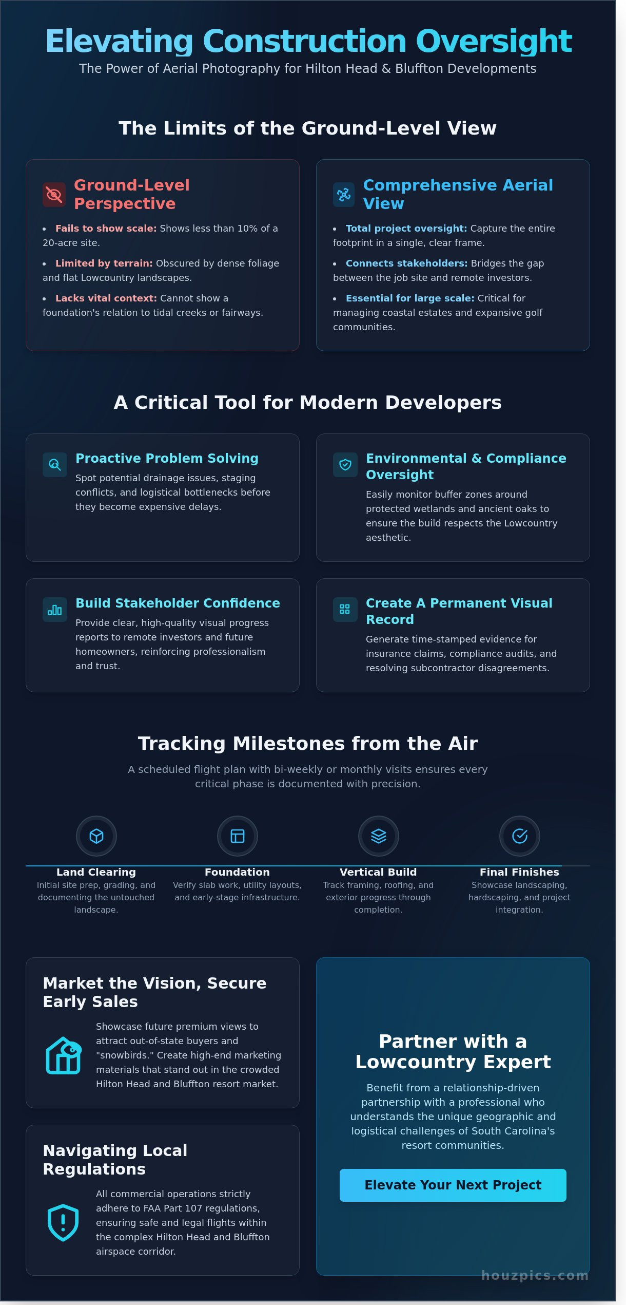
Marketing the Vision: Attracting Out-of-State Buyers and Snowbirds
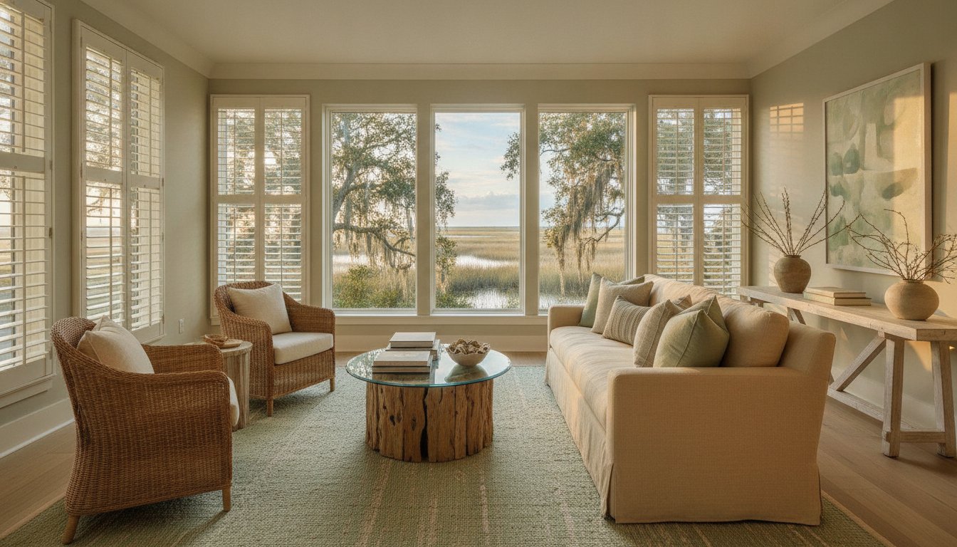
Selling a luxury home in the Lowcountry often starts before the foundation is even poured. For out-of-state buyers and snowbirds, a Hilton Head property represents a major lifestyle shift. These purchasers need to see the finished vision to feel comfortable committing. Using aerial photography for construction projects hilton head provides that necessary clarity. We fly drones to the exact height of future second-story balconies or rooftop decks. This allows a buyer to see their actual future view of the Atlantic Ocean or a fairway in Sea Pines. It creates an immediate emotional connection that a flat blueprint simply cannot match.
Roughly 40% of luxury buyers in our resort markets originate from outside South Carolina. These clients can't visit the job site every weekend to check on progress. High-resolution aerial imagery bridges that gap. It transforms a dusty construction site into a tangible future home. By showing the relationship between the structure and the surrounding landscape, developers can justify premium pricing early in the build cycle.
Selling the Lifestyle, Not Just the Structure
Hilton Head is defined by its amenities. Buyers look for proximity to private marinas, beach clubs, and championship golf courses. We use aerial views to show how a new build sits within these resort communities. Capturing the Lowcountry at twilight adds a level of drama that resonates with high-end clientele. These shots highlight the natural beauty of the marsh and the iconic Spanish moss. This high-altitude perspective works alongside our professional property photography services to create a complete marketing story. It moves the sales conversation from construction materials to the daily experience of living in the Lowcountry.
Pre-Selling Units and Custom Estates
Securing early deposits is essential for managing project cash flow. Aerial updates act as undeniable proof of progress for buyers in the Northeast or Midwest. These consistent visuals reduce buyer anxiety during the 12 to 18 months it typically takes to finish a custom estate. A 2023 study from California Polytechnic State University on the benefits of drone technology highlights how visual data improves communication and trust between developers and stakeholders. In a local market where many buyers are remote, this transparency is a major competitive edge. It shortens the sales cycle and helps developers move on to their next project with confidence.
Navigating Local Regulations and Airspace in the Lowcountry
Operating drones in the Lowcountry requires more than just high-end equipment. It requires a deep understanding of federal and local laws that govern our skies. Every commercial flight must adhere to FAA Part 107 regulations. This isn't a suggestion; it's a federal requirement for any project where the imagery is used for business purposes. For developers, this means ensuring your pilot holds a current Remote Pilot Certificate. This certification is the foundation of site safety and liability protection on a busy job site.
The Hilton Head Airport (HHH) creates a specific challenge for aerial photography for construction projects hilton head. Much of the island falls within Class D controlled airspace. Pilots can't simply take off whenever they choose. They must secure LAANC (Low Altitude Authorization and Notification Capability) authorizations before the propellers start spinning. We handle these digital handshakes with air traffic control daily, ensuring your project remains compliant and avoids federal fines that can reach thousands of dollars.
FAA Compliance and Site Safety
Part 107 certification does more than keep the FAA happy. It provides the necessary framework for insurance coverage. Most commercial liability policies for drone operations are void if the pilot isn't licensed. On an active construction site, this risk is too high to ignore. We coordinate directly with site supervisors to manage flights over ground crews. Our pilots follow strict protocols to avoid disrupting active work zones. We also manage complex authorizations near sensitive areas like the Beaufort County Sheriff’s Office or municipal buildings, ensuring every shot is captured legally.
Gated Community and POA Protocols
Hilton Head and Bluffton are defined by their gated communities. Places like Palmetto Bluff, Sea Pines, and Sun City have their own private rules regarding drone usage. These Property Owners Associations (POAs) often require advance notice or specific flight windows to protect resident privacy. We take a quiet professional approach. This means using low-noise propellers and maintaining respectful distances from occupied coastal homes. We don't want to draw unnecessary attention to the job site.
Working with local security teams is part of our routine. We coordinate entry and flight times so your progress photos don't trigger security complaints. This relationship-driven approach keeps your project moving without friction from the neighbors. Hiring a local expert who knows the security gate protocols at Wexford or the management office at Hampton Hall is more efficient than a DIY attempt. It ensures the job is done right the first time without legal headaches.
Partnering with Houzpics for Your Next Project
For 30 years, Houzpics has documented the evolution of the South Carolina Lowcountry. We've spent three decades capturing the unique beauty and technical complexity of developments across Hilton Head and Bluffton. This deep local experience means we understand the specific lighting, coastal weather patterns, and environmental regulations that define construction in our region. We aren't just photographers; we're seasoned professionals who know how to showcase the progress of a site while respecting the landscape.
Our approach is relationship-driven. We don't view ourselves as a simple vendor, but as a partner in your project’s success. We know that your growth reflects our own. Whether you need raw progression shots for internal stakeholders or polished marketing videos to captivate out-of-state buyers, our comprehensive service packages cover every phase of the build. We've designed our workflow to be as efficient as possible for busy developers.
Our Commitment to Quality and Consistency
Quality isn't an accident; it's a standard we maintain through our in-house editing team. Every frame is reviewed to ensure it meets our award-winning criteria before it reaches your portal. We don't outsource this critical step. This internal control allows us to maintain factual integrity and visual excellence across every shoot. We also understand that construction milestones are time-sensitive. Our scheduling is dependable, ensuring we arrive on-site when you need us without disrupting your crew's operations.
Ready to Elevate Your Project?
High-quality aerial photography for construction projects hilton head supports your project from the first shovel in the ground to the final unit sale. It provides the visual proof required for investor updates and the aspirational imagery needed for resort market listings. We invite you to discuss custom progression plans for your upcoming developments in Hilton Head, Bluffton, or Okatie. Our team is ready to provide the professional perspective your project deserves. Book your first site survey today.
Maximize Your Development Results in the Lowcountry
Managing a build in Hilton Head requires more than just boots on the ground. You need a bird's-eye view to track milestones and maintain clear communication with investors and clients. High-quality visuals do more than just record progress; they help you sell the vision to out-of-state buyers before the foundation is even poured. Using professional aerial photography for construction projects hilton head ensures your site remains compliant with local regulations while providing the marketing assets needed to stand out in a competitive resort market.
Houzpics brings 30 years of Lowcountry experience to your job site. Our award-winning creative team is FAA Part 107 Licensed and Insured; we handle the technical complexities of local airspace so you don't have to. We've spent three decades helping developers showcase their work with precision and clarity. Your project deserves a partner who understands the specific needs of our unique coastal landscape.
Elevate your next project, book your construction aerials now
We look forward to helping you document your next success story from the air.
Frequently Asked Questions
Do I need a permit for drone photography on my Hilton Head construction site?
You don't need a specific municipal permit from the Town of Hilton Head Island for drone flights on private property, but your pilot must hold an FAA Part 107 commercial certification. This federal requirement ensures that the flight complies with airspace regulations and safety standards. Since 2016, the FAA has mandated these licenses for any aerial photography for construction projects hilton head to ensure professional accountability and site safety.
How often should I have aerial photos taken of my project?
Most developers schedule flights every 30 days to document progress for stakeholders and lenders. For high-velocity builds or critical foundation phases, bi-weekly captures provide the granular detail needed for project management. Regular intervals create a reliable timeline that helps resolve 100 percent of potential disputes regarding site conditions or subcontractor timelines during the build process.
Can you fly drones in gated communities like Palmetto Bluff or Sea Pines?
You can fly drones in these communities, but you must coordinate with the Property Owners Association (POA) and security 48 hours in advance. Sea Pines and Palmetto Bluff have specific protocols for commercial vendors to ensure resident privacy and safety. We handle these logistics directly with the gate house to ensure our team has authorized access and the necessary decals for entry.
What is the difference between a standard drone photo and an orthomosaic map?
A standard drone photo is a single perspective shot used for marketing or general site overviews. An orthomosaic map is a high-resolution top-down view created by stitching together 100 or more individual images into one geometrically corrected map. These maps allow you to take precise measurements of the site with 99 percent accuracy, which is essential for site planning and grading checks in Lowcountry resort communities.
How do aerial photos help with out-of-state buyers?
Aerial photos bridge the gap for the 70 percent of Hilton Head buyers who reside outside of South Carolina. Providing high-definition progress shots allows these clients to see their investment grow without traveling to the Lowcountry. This transparency shortens the sales cycle and builds the confidence required for buyers to make decisions from states like Ohio, Pennsylvania, or New York.
Is it safe to fly drones while my crew is working on-site?
It's safe to fly while crews are working as long as the pilot follows FAA rules regarding flight over people. We use specialized lenses to capture close-up details from a safe distance, ensuring we don't distract workers or create hazards on the ground. This allows us to document active site conditions without stopping your production schedule for a single hour.
What happens if my project is in a restricted flight zone near the airport?
If your project is within 5 miles of the Hilton Head Island Airport, we must obtain LAANC authorization before taking off. This digital system provides real-time clearance from the FAA to fly in controlled airspace safely. We manage this technical process for every aerial photography for construction projects hilton head to ensure your project remains compliant with federal aviation law at all times.